
Page 24 - Historical Study of Yerba Buena Island, Treasure Island and Their Buildings
P. 24
Chapter 1 Y erba Buena Island
1.1 Introduction
Situated in the middle of the San Francisco Bay, easily visible from San Francisco, Oakland and
most of the towns of the San Francisco Peninsula and the Contra Costa ( coastline opposite the
San Francisco Peninsula), Yerba Buena Island has long been a magnet for legends and
ambitions. It is the southernmost of the three major islands of the Bay. The other two islands
are Angel Island to the northwest and Alcatraz Island to the west of Y erba Buena Island.
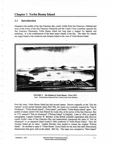
FIGURE 3: The Hamlet of Yerba Buena. Circa 1835.
Note: Yerba Buena Island and the Contra Costa in the distance.
Over the years, Y erba Buena Island has had several names. Known originally as the "Isla del
Carmen" on the earliest Spanish charts (Ref. BB), the island was eventually renamed the "Isla de
Alcatraces", "Yerba Buena Island", "Goat Island", and finally "Yerba Buena Island" again. This
parade of names started with Juan Manuel de Ayala who, in his survey of the San Francisco Bay
in 1775, named it "Isla de Alcatraces" ("Pelican Island" in English). Later in 1826, an English
cartographer, Captain Frederick W. Beechey of the British scientific exploration ship Blossom
copied Ayala's map of San Francisco Bay and inadvertently transposed the name of "Isla de
Alcatraces" to an unnamed island located a little northwest of Y erba Buena Island. Thus did
Alcatraz Island get its name. Captain Beechey then needed to rename the original "Pelican
Island". He decided to name it "Yerba Buena" (Good Herb) for the mint like herb (Micromeria
chamissonis) that grew wild on the island. (Ref. K). This name was corrupted to "Mint Island"
September I, 1995 Historical Study ofYerba Buena Island, 1-1
Treasure Island, and their Buildings